Geographic Information System – GIS

September 29th,  2017

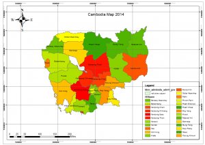
Geographic Information System (GIS) is a project that I am currently a part of. Within the project, we will be off campus every Friday and spend an hour and a half to learn about geographic mapping. Before entering the course, when I think of map I could only think of a big piece of paper that represents geography. Besides what I learned in GIS, a map is not just a piece of paper that represents geography, but it also shows informant about places as well. It could be pictures or a written history that could give researchers more ideas about the geography.  In class,  also learned how to use a software called ArcMap, which allows me to create my own map.  

Trip to iThinkAsia

iThinkAsia is an animation studio that is located in Phnom Penh. This was part of the Animation exploration that I had involved in. We went there to learn about the process of animation as well as to get a sense of what animators around the world do to get their animated project out for the world to see. At there, we also learned about an animated program called Opentoonz, where we were required to animate a bouncing ball motion. I enjoyed it a lot and I found it really interesting that within a movie that us, the audiences don’t even pay attention to it, but there was so many other knowledge that is required for a movie to make things seems real with physics related to a motion of an object.